What is Ntrip? How to use Ntrip and TCS with Oscar?
Zoe Zhao, Tersus GNSS 30 March, 2022
To perform an accurate RTK survey, you usually need a base transfering differential correction data to a rover in real-time. You can either use your own base or from CORS providers using a technology called NTRIP.
NTRIP, the Networked Transport of RTCM via Internet Protocol, was developed by the Federal Agency for Cartography and Geodesy of Germany in 2014, enables streaming of RTK correction data via the internet.
How does NTRIP work?
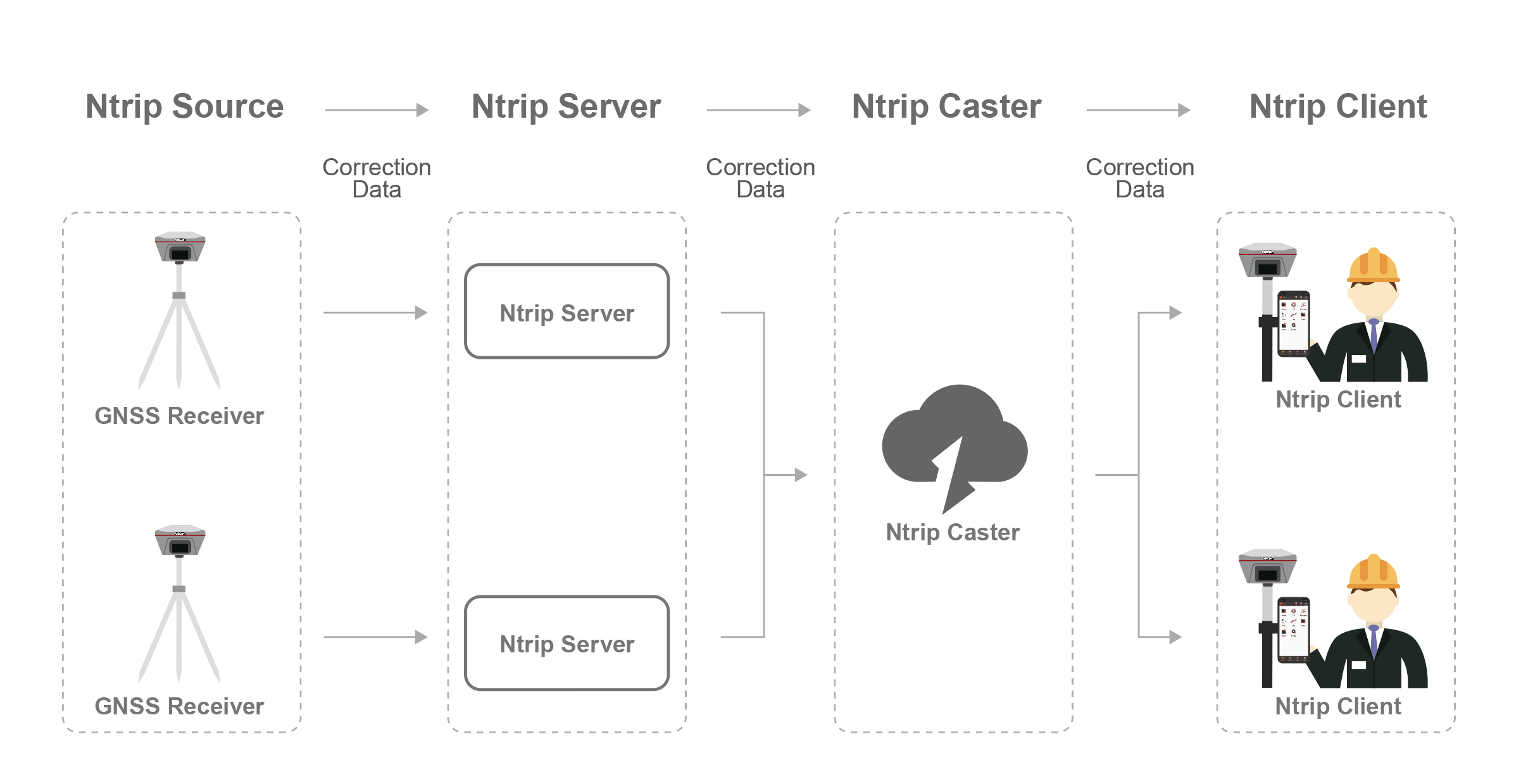
--->The Ntrip Source is responsible for generating GNSS correction data and submitting to the Ntrip Server;
--->The Ntrip Server is a PC or on-board computer running Ntrip Server software communicating directly with a GNSS reference station. The Ntrip Server serves as the intermediary between the GNSS receiver (Ntrip Source) streaming RTCM data and the Ntrip Caster.
--->The Ntrip Caster is a HTTP server which receives streaming RTCM data from one or more Ntrip Servers and in turn streams the RTCM data to one or more Ntrip Client via the internet.
--->The Ntrip Client receives streaming RTCM data from the Ntrip Caster to apply as real-time corrections to a moving GNSS receiver.
Note:
Ntrip Source and Ntrip Server are generally integrated into the base station. The base station generates correction data (playing the role of Ntrip Source), and then sends it to Ntrip Caster (playing the role of Ntrip Server) through the network. Of course, Ntrip Source and Ntrip Server can also be Separate: The base station generates correction data (playing the role of Ntrip Source), and then sends it to a program through the serial port, and this program (playing the role of Ntrip Server) sends the correction data to Ntrip Caster.
Ntrip Caster is generally a server with a fixed IP address, which is responsible for receiving and sending correction data. There are two solutions when sending correction data to Ntrip Client: one is to directly forward the correction data generated by Ntrip Source; the other is to generate a virtual base station for Ntrip Client by solving the correction data of multiple Ntrip Sources, that's VRS.
Advantages of Using NTRIP
More convenient and popular: Carry out measurement work only with one rover, avoiding the radio interference and distance limitation problems of traditional radio communication;
Reference station sharing: Multiple Ntrip Server (RTK reference stations) spread over a large area can be connected to Ntrip Caster. At the same time the Ntrip Client within this range can choose a specific mount point, effectively deciding which reference station he wishes to receive correction data from (usually the one closest to his current location).
Security: Only the authorized users (username and password required) can receive correction data. Ntrip Caster is also able to "protect" data receiving from Ntrip Server, NtripCaster can monitor if the rover has been logged in and how long each rover is online, and even prevents RTK rover from connecting directly to a reference station.
Limits of using NTRIP
Being dependent on the Internet: NTRIP only works via the Internet, so the work area should be in range of cellular service for receiving corrections data via the Internet.
Fees: Some NTRIP networks are private or for special governmental use, so you need to pay for using them. Sometimes it can get really expensive, so do your research beforehand.
How to use NTRIP and TCS with Oscar?
The operations of Tersus surveying software Nuwa setting the receiver to connect to the NTRIP are as follows:
Step1:
To get access to the NTRIP network, you need to contact your local NTRIP service to create an account. Some of the NTRIP networks are run by states and are free of charge, some of them are private and are pretty costly when it comes to the subscription fees. Also, Tersus provides the mature Geobee30 CORS solution, click for details;
Step2:
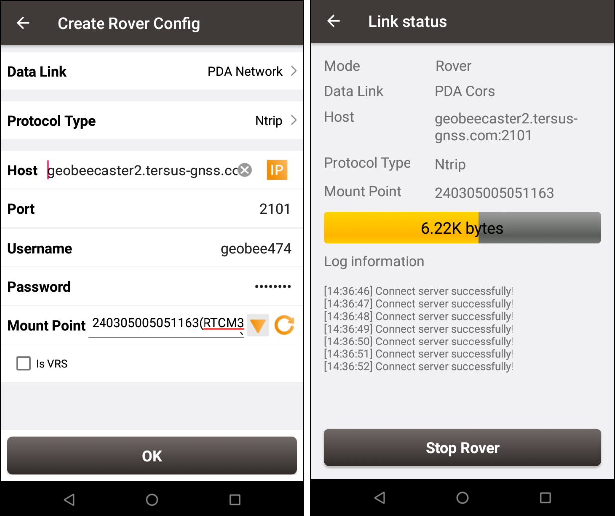
Choose "Ntrip" protocol for Rover, you can use "PDA Network" or "Receiver Network" (with a sim-card inserted), input the "IP" and "Port", fill in the authorized "Username" and "Password". Click the refresh icon to get "Mount Point" automatically. After all settings are finished start the Rover, then you will see the status of the Rover connecting to the Ntrip service.

Tersus provides TCS (Tersus Caster service) to transfer correction data. It allows working with one base station and multiple rover stations at a time free of charge, without radio, just transmit and receive correction data through network.
Compared with NTRIP, TCS does not require a fixed CORS station; the operation is simpler, no need to enter the username and password, and it can be connected according to the serial number of the base station. The free server is built into the Nuwa software. you can select the server in the list when you use the TCS protocol.
The operations of Tersus surveying software Nuwa setting the receiver to connect to the TCS are as follows:
Step1:
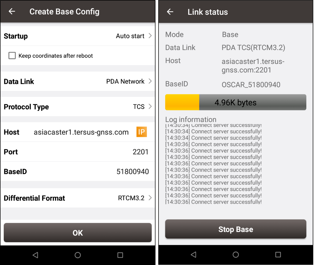
Choose "TCS" protocol for Base station, you can use "PDA Network" or "Receiver Network" (with a sim-card inserted), input the "IP" and "Port", "Base ID" is filled in automatically by the serial number. Choose the "Differential Format" as RTCM3.2. After all settings are finished start the Base station, then you will see the status of the Base connecting to the TCS service.

Step2:
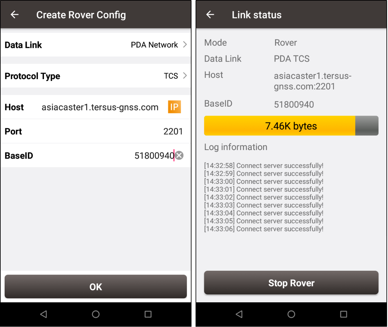
Choose TCS protocol for Rover, you can use "PDA Network" or "Receiver Network" (with a sim-card inserted). "Base ID" is the serial number of the Base station to be connected to. After all settings are finished start the Rover, then you will see the status of the Rover connecting to the TCS service.

About Tersus GNSS Inc.
Tersus GNSS is a leading Global Navigation Satellite System (GNSS) solution provider. Our offerings and services aim to make centimeter-precision positioning affordable for large-scale deployment.
Founded in 2014, we have been pioneers in design and development GNSS RTK products to better cater to the industry’s needs. Our portfolios cover GNSS RTK & PPK OEM boards, David GNSS Receiver, Oscar GNSS Receiver, MatrixRTK [GNSS CORS Systems] and inertial navigation systems.
Designed for ease of use, our solutions support multi-GNSS and provide flexible interfaces for a variety of applications, such as UAVs, surveying, mapping, precision agriculture, lane-level navigation, construction engineering, and deformation monitoring.
Sales inquiry: sales@tersus-gnss.com
Technical support: support@tersus-gnss.com
