Coordinate System? Parameters?
Site Calibration?(II)
Zoe Zhao, Tersus GNSS 12 July, 2022
We explained the Coordinate System in section I of the article: Coordinate System, Parameter, Site Calibration(I), so this time we will try to make you understand the following 2 parts: Parameters and Site Calibration.
Part 2 Parameters
Parameters" is a solution by converting the WGS84 ellipsoid datum to a local ellipsoid datum.
The Bursa seven-parameter has been mentioned above in the Coordinate System - Datum Transformation, and the parameters must be known before they can be filled. In most cases the parameters are unknown, but can be calculated from the known points, which is the function of “Parameters”.
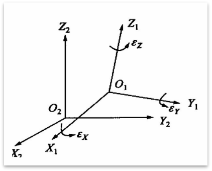
Seven-parameter: When converting between two different three-dimensional Space Cartesian Coordinate Systems (different datums), a seven-parameter model is usually used. As the name implies, there are seven unknown parameters.
● 3-Translation vector: Contains the three translations along the coordinate axes, △X, △Y, △Z
● 3-Rotation matrix. Consists of three axes (small rotations around each of the three coordinate axes) rx ,ry,rz. The rotation matrix is an orthogonal matrix. The angles are given in either degrees or radians.
● 1-Scale factor, which is unitless; if it is given in ppm, it must be divided by 1,000,000 and added to 1.
When “Parameters” is completed and the result is applied, the seven-parameter or three-parameter will be updated to the current coordinate system synchronously in the Nuwa app.
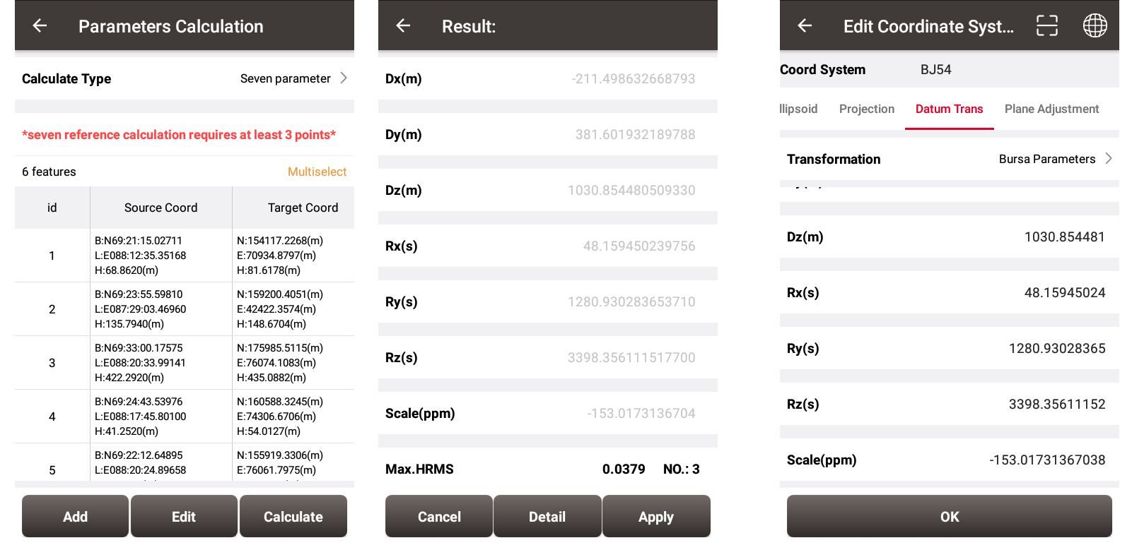
Note the unit is ppm here, so the scale factor is 1+(-153/1000000)=0.999847
Three-parameter: It is a simplified version of seven-parameter, that is, there are only 3-translation vector, and no 3-Rotation matrix and 1-scale factor.
Part 3 Site Calibration
"Site Calibration” is used to find the mathematical transformation relationship (transformation parameters) between WGS84 and the local planar Cartesian coordinate system.
Plane Adjustment /Height Fitting have been mentioned above in Coordinate System, which can only be filled in if the parameters are known.In most cases the parameters are unknown, but can be calculated from the known points, which is the “Site Calibration” function. ![]()
There are three calculation types: “Four-parameter”, “Height Fitting”, “Four-parameter + Height Fitting”.
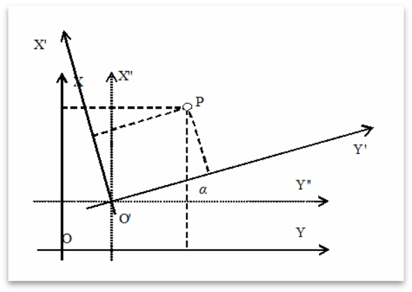
Four-parameter:When converting between two different two-dimensional plane rectangular coordinate systems, a four-parameter model is usually used. As the name implies, there are four unknown parameters in the model.
● 2-Translation vector: Contains the two translations along the coordinate axes, △X, △Y,
● 1-Rotation matrixe: By rotating an angle, the X and Y axes of the two coordinate systems can be coincident.
● 1-Scale factor: that is, the ratio of the lengths of the same straight line in the two coordinate systems. Usually the value is almost equal to 1.
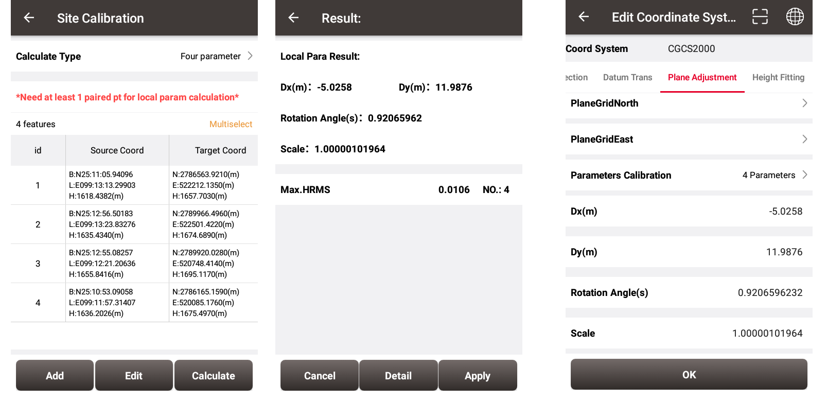
When the “Site Calibration” is completed and the four-parameter result is applied, the plane parameters will be updated to the current coordinate system synchronously in the Nuwa app.
![]()
Height fitting: contains three methods
● Fixed difference correction: 1 known point required
● Plane fitting: 3 known points are required
● Surface fitting: 6 known points are required
Surface fitting requires the most control points, and the fitting effect is the best. In actual measurement, a suitable method needs to be selected according to the number of known points and accuracy requirements.
The same as the four parameter, when the height-fitting result is applied, the plane parameters will be updated to the current coordinate system synchronously in the Nuwa app.
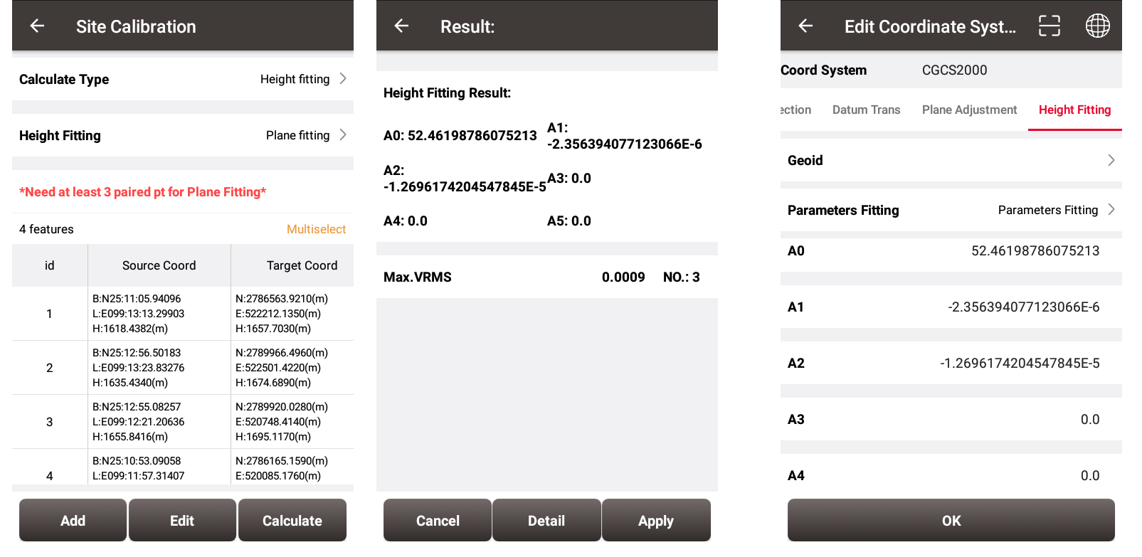
Four-parameter + Height fitting: a combination of the above two methods, the plane and elevation are fitted simultaneously.
Finally, the functions of “Coordinate System”, “Parameters”, and “Site Calibration” have been explained in detail above. Do you still have some questions about when to use “Parameters” and “Site Calibration”?
△ The seven-parameter model in “Parameter” is a relatively strict coordinate transformation model. The seven-parameter model needs to convert Projected Coordinate System or Geodetic Coordinate System to Space Cartesian Coordinate System first, and then establish a transformation model between the two Space Cartesian Coordinate System. There is no precision loss in the transformation between Space Cartesian Coordinate System to Geodetic Coordinate System or Geodetic Coordinate System, so the seven-parameter accuracy will not be affected by projection deformation and is suitable for a wide range with high conversion accuracy. But the calculation is more complicated.
△ The four-parameter model does not consider the deformation inconsistency caused by ellipsoid and projection. It is only suitable for small-scale area. The advantage is that the model is simple, easy to calculate, and does not need to know projection parameters, ellipsoid parameters, etc. As long as it is a conversion between two Plane Coordinate Systems, the four-parameter model can be used to calculate the parameters through two or more known points. However, the four-parameter model assumes that the relationship between the two Plane Coordinate Systems is a linear change, for the two Projected Coordinate Systems between different ellipsoids do not meet this assumption. So the farther away from the central meridian, the greater the deformation. , and the deformation is smaller near the central meridian. Therefore, for a larger-scale area, the calculation error using four-parameter will be larger.
In actual surveying work, the following three situations may be used.
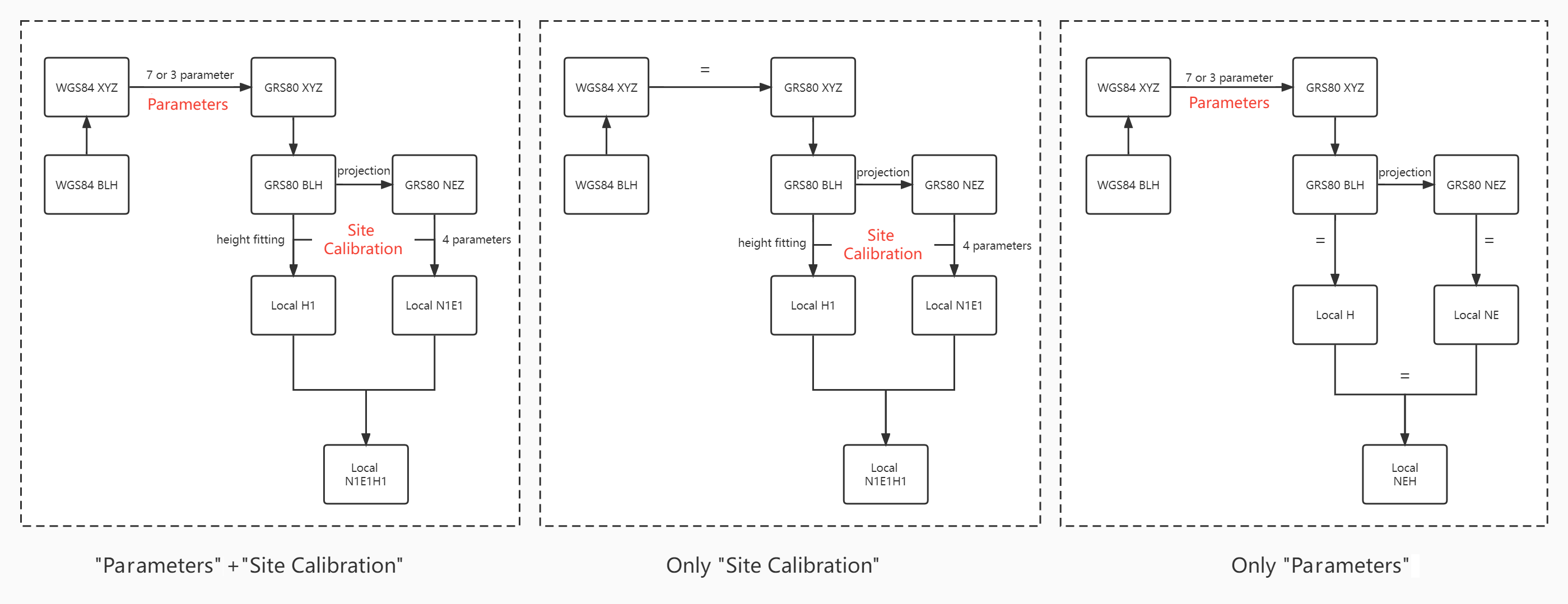
In a word, the method needs to be selected according to the comprehensive evaluation of "control points number, coordinate system information and accuracy requirements". The following recommendations are for reference only:
● "Parameter"-"seven-parameter": This method can cover a long distance range, usually the distance is more than 15 km, the ellipsoid used by two different coordinate systems must be considered, so as to avoid the low accuracy caused by the difference of the ellipsoid parameters. Before the calculation, at least three known points are required in the local datum and the WGS84 system, which should be evenly distributed around the survey area and the center of the survey area. Use the three-dimensional constraint adjustment results in the WGS-84 coordinate system of the entire network and the two-dimensional constrained adjustment results of the local coordinate system and the height calculation of each point, which are more complicated.
● "Parameter"-"three-parameter": rarely used, it is recommended to use it in a flat place within 5km.
● "Site Calibration"-"Four-parameter": This method is recommended to be used in a small area, usually the point distance is within 10 km, we can almost ignore the influence of different ellipsoids on the conversion accuracy. At least two known points are required, which can be obtained by using any two known points with three-dimensional coordinates, which is relatively simple.
About Tersus GNSS Inc.
Tersus GNSS is a leading Global Navigation Satellite System (GNSS) solution provider. Our offerings and services aim to make centimeter-precision positioning affordable for large-scale deployment.
Founded in 2014, we have been pioneers in design and development GNSS RTK products to better cater to the industry’s needs. Our portfolios cover GNSS RTK & PPK OEM boards, David GNSS Receiver, Oscar GNSS Receiver, MatrixRTK [GNSS CORS Systems] and inertial navigation systems.
Designed for ease of use, our solutions support multi-GNSS and provide flexible interfaces for a variety of applications, such as UAVs, surveying, mapping, precision agriculture, lane-level navigation, construction engineering, and deformation monitoring.
Sales inquiry: sales@tersus-gnss.com
Technical support: support@tersus-gnss.com
