Coordinate System? Parameters?
Site Calibration?(I)
Zoe Zhao, Tersus GNSS 8 July, 2022
Coordinate System? Parameters? Site Calibration? Are you confused with these functions sometimes?
First of all, their purposes are to obtain the final local coordinates, and some inconspicuous changes may affect the final result, caused coordinates error. Let's take a picture to get a glimpse of their intricate relationship.
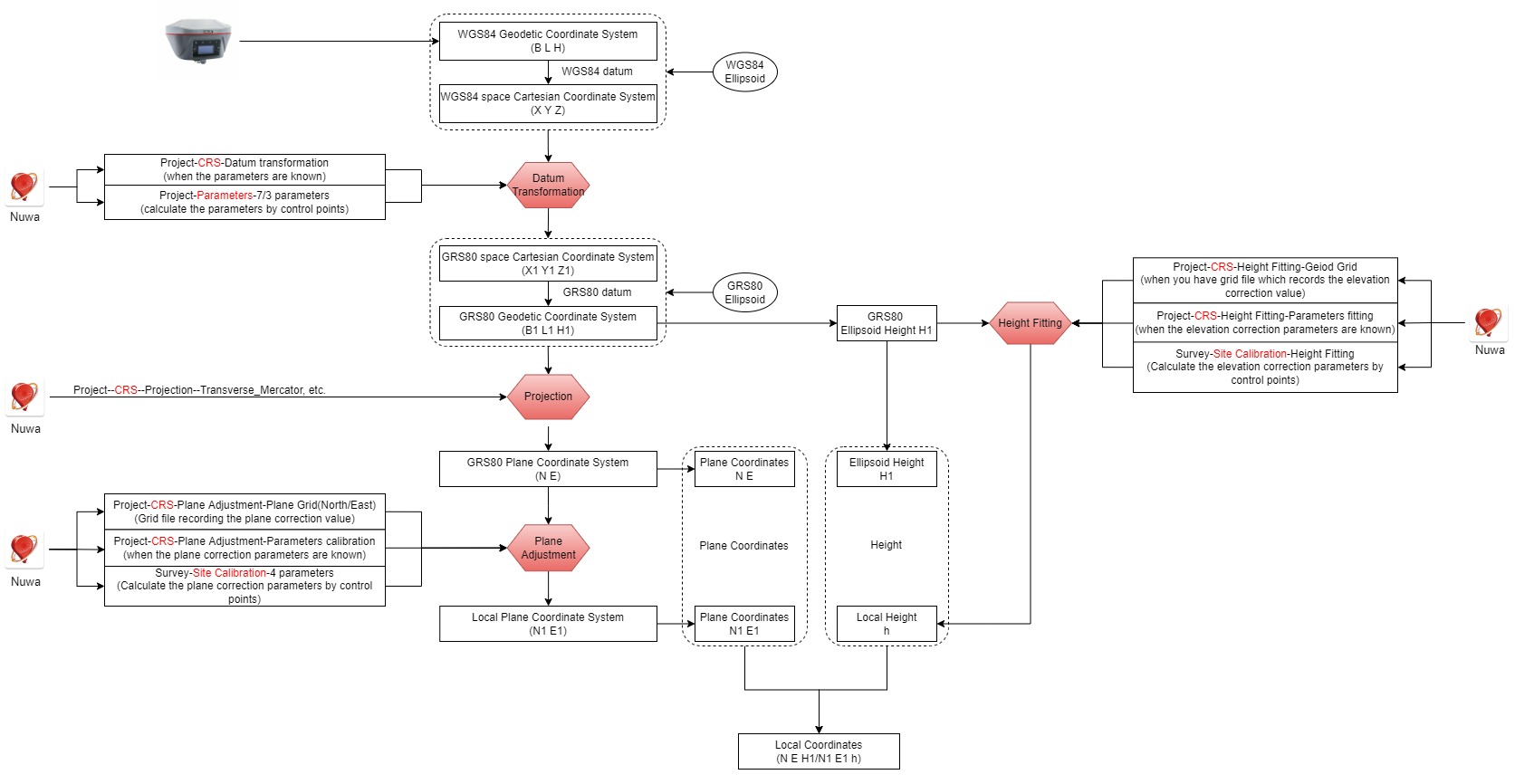
↑ CRS means Coordinate Reference System ↑
Next, the functions are explained one by one.
Part 1 Coordinate System
△ Geographic Coordinate System(GCS) is a spherical or ellipsoidal coordinate system for measuring and communicating positions directly on the Earth as latitude and longitude. It is the simplest, oldest and most widely used of the various of spatial reference systems that are in use, and forms the basis for most others. Although latitude and longitude form a coordinate tuple like a Cartesian Coordinate System, the geographic coordinate system is not Cartesian because the measurements are angles and are not on a planar surface.
△ Projected Coordinate System: also known as a projected coordinate reference system, a planar coordinate system, or grid reference system, is a type of spatial reference system that represents locations on the Earth using Cartesian Coordinates (x,y) on a planar surface created by a particular map projection.
The coordinate system function in Nuwa includes five setting options: Ellipsoid, Projection, Datum Transformation, Plane Adjustment, and Height fitting.
Ellipsoid—the reference ellipsoid
As we all know, the surface of our earth is uneven, and for earth measurement, the surface cannot be expressed by mathematical formulas, and such a surface cannot be used as a datum for measurement and mapping.
In geodesy, a Reference Ellipsoid is a mathematically defined surface that approximates the geoid, which is the truer, imperfect figure of the Earth, or other planetary body, as opposed to a perfect, smooth, and unaltered sphere, which factors in the undulations of the bodies' gravity due to variations in the composition and density of the interior, as well as the subsequent flattening caused by the centrifugal force from the rotation of these massive objects (for planetary bodies that do rotate). Because of their relative simplicity, reference ellipsoids are used as a preferred surface on which geodetic network computations are performed and point coordinates such as latitude, longitude, and elevation are defined.
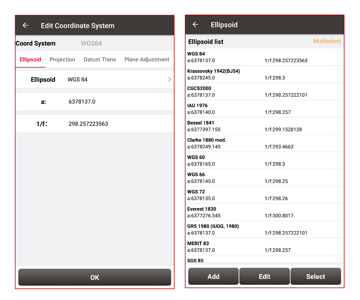
The following table lists some of the most common reference ellipsoids:

Nuwa software supports some current mainstream reference ellipsoids, and it also support to add new one according to needs.
Datum Transform—to define the datum
Before understanding the datum transformation, it is necessary to understand the concept of geodetic datum and the relationship between datum and ellipsoid.
A geodetic datum or geodetic system (also: geodetic reference datum, geodetic reference system, or geodetic reference frame) is a global datum reference or reference frame for precisely representing the position of locations on Earth or other planetary bodies by means of geodetic coordinates. A horizontal datum is used to measure a location across the Earth's surface, in latitude and longitude or another coordinate system; a vertical datum is used to measure the elevation or depth relative to a standard origin, such as Mean Sea Level (MSL).
Because Earth is an imperfect ellipsoid, local datums can give a more accurate representation of some specific area of coverage than WGS 84 can. OSGB36, for example, is a better approximation to the geoid covering the British Isles than the global WGS 84 ellipsoid. However, as the benefits of a global system outweigh the greater accuracy, the global WGS 84 datum has become widely adopted.
The relationship between the ellipsoid and the datum is one-to-many, that is, the datum is established on the basis of the ellipsoid, but the ellipsoid cannot represent the datum, and the same ellipsoid can define different datums. The datum is combined with the ellipsoid to approximate the Earth's surface.
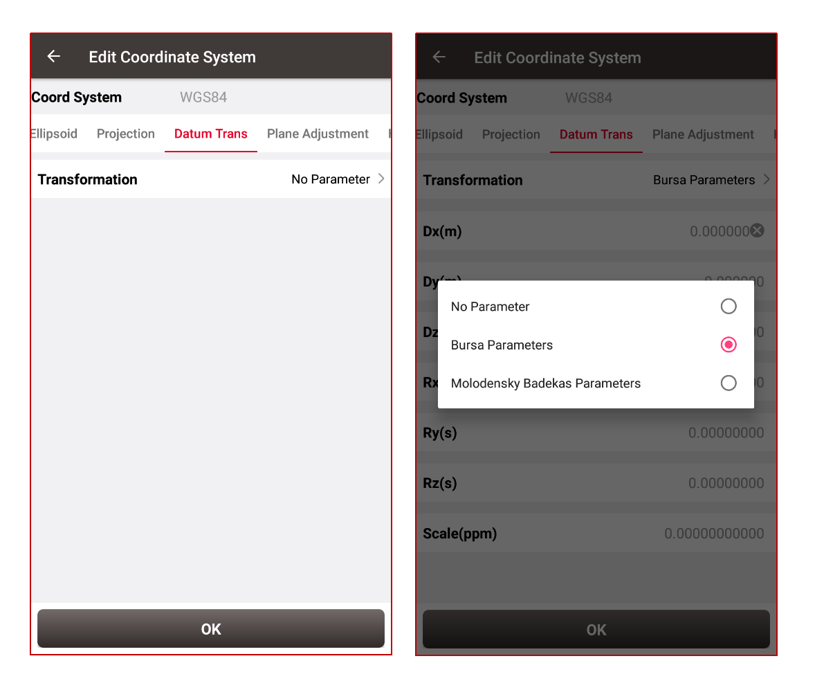
The datum is generally defined by the transformation parameters from WGS1984 to the local datum. The datum transformation can be used between different datums of the same ellipsoid, or between different ellipsoids.
Nuwa software supports "Helmert transformation (Bursa seven-parameter)" and "Molodensky-Badekas transformation (ten parameters)". When the parameters are known, select the method and input it. When the parameters are unknown, they can be calculated by the known points, and the detailed information will be described in the "Parameters" function later.
Projection—
In cartography, map projection is the term used to describe a broad set of transformations employed to represent the two-dimensional curved surface of a globe on a plane. In a map projection, coordinates, often expressed as latitude and longitude, of locations from the surface of the globe are transformed to coordinates on a plane. Projection is a necessary step in creating a two-dimensional map and is one of the essential elements of cartography.
All projections of a sphere on a plane necessarily distort the surface in some way and to some extent. Depending on the purpose of the map, some distortions are acceptable and others are not; therefore, different map projections exist in order to preserve some properties of the sphere-like body at the expense of other properties. The study of map projections is primarily about the characterization of their distortions.
The most well-known map projection is the Mercator projection.
Taking the Transverse Mercator Projection as an example, it is generally necessary to pay attention to these parameters:
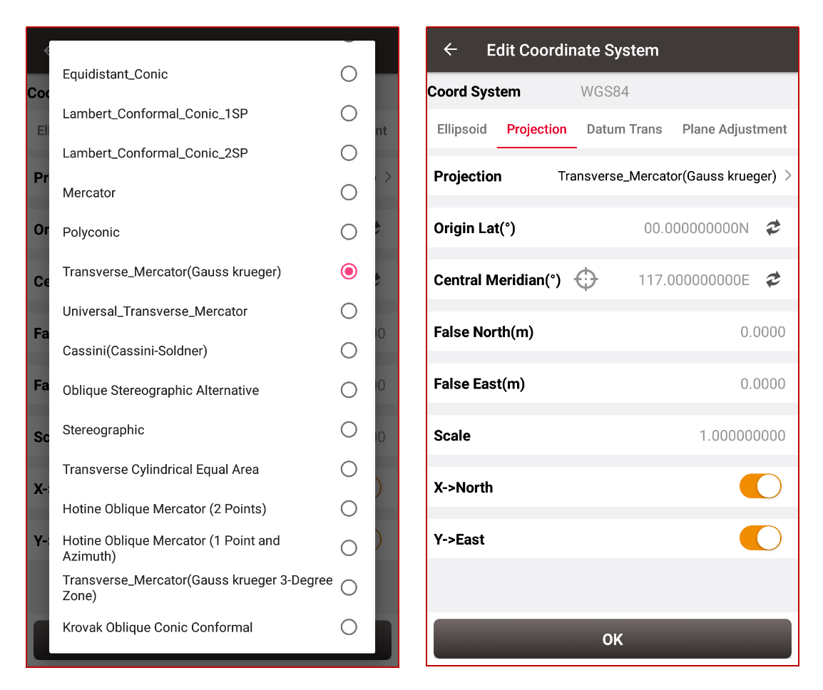
● Origin Lat(°): 0 by default
● Central Meridian(°): You can click  to get it automatically when the receiver gets satellite signals, or you can enter it manually
● False East (m): 500,000 by default
The linear value added to all x-coordinates of a map projection so that none of the values in the geographic resgion being mapped are negative. The point of origin of each UTM zone is the intersection of the equator and the central meridian of each zone. To avoid dealing with negative numbers the central meridian of each zone is set at 500,000 meters East.
● False North (m): 10,000,000 or 0
In the northern hemisphere it’s 0. And in the southern hemisphere it’s 10,000,000. The linear value added to all y-coordinates of a map projection so that none of the values in the geographic region being mapped are negative. The northing at the equator is set at 10,000,000 meters so no point has a negative value.
● Scale: 0.9996 by default
The main function of Plane Adjustment and Height Fitting is to add the correction value, which can improve the accuracy.
Plane Transformation—contains Plane Grid and Parameter Calibration
● Plane Grid includes PlaneGridNorth and PlaneGridNorthEast recording the correction value in forms of grid. After selecting the grid file, the correction value will be added to the plane coordinates and the more accurate plane coordinates will be obtained. The formats are supported by Nuwa: ggf, grd, gsf and osgb.
● Parameter Calibration is to input four known parameters of DX, DY, Rotation Angle and Scale to obtain the final more accurate plane coordinates. When the parameters are unknown, they can be calculated by the known points. The detailed information will be described in the "Site Calibration" function later.
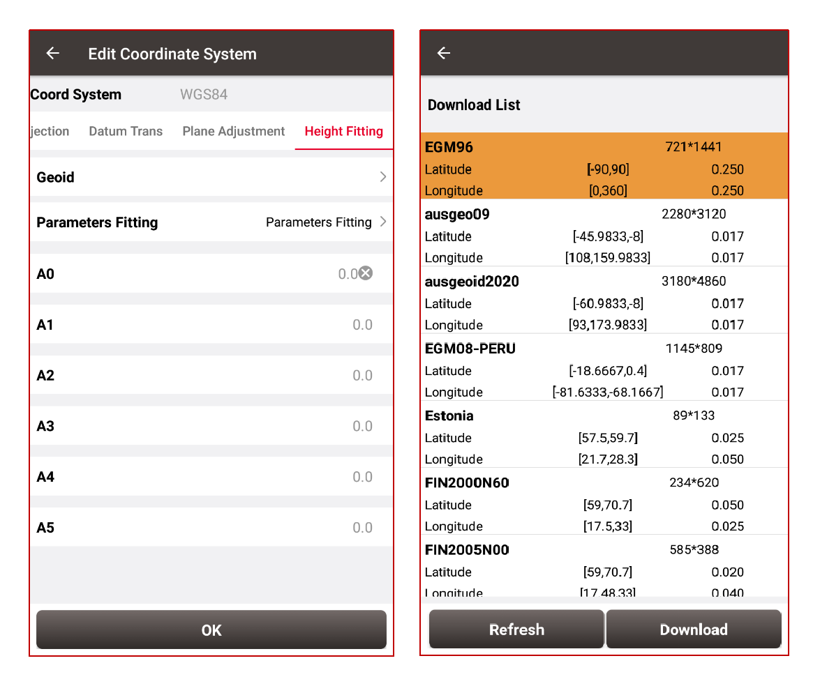
Height fitting—contains Geoid and Parameters fitting
The elevation obtained by GPS measurement is the WGS84 geodetic height, and different countries have different starting planes.
● Geoid model: The geoid undulation, geoid height, or geoid anomaly is the height of the geoid relative to a given ellipsoid of reference. The undulation is not standardized, as different countries use different Mean Sea Levels as reference, but most commonly refers to the EGM96 geoid and EGM2008 geoid. After selecting the grid file, the correction value will be added and the more accurate height value will be obtained. The formats are supported by Nuwa: ggf, grd, gsf, osgb and mnt.
● Parameter Calibration is to input known elevation-related parameters to obtain the final more accurate elevation value. When the parameters are unknown, they can be calculated by the known points. The detailed information will be described in the "Site Calibration" function later.
We will explain other two concepts Parameters and Site Calibration in section II of this article, you can read this: Coordinate System, Parameters, Site Calibration(II)
About Tersus GNSS Inc.
Tersus GNSS is a leading Global Navigation Satellite System (GNSS) solution provider. Our offerings and services aim to make centimeter-precision positioning affordable for large-scale deployment.
Founded in 2014, we have been pioneers in design and development GNSS RTK products to better cater to the industry’s needs. Our portfolios cover GNSS RTK & PPK OEM boards, David GNSS Receiver, Oscar GNSS Receiver, MatrixRTK [GNSS CORS Systems] and inertial navigation systems.
Designed for ease of use, our solutions support multi-GNSS and provide flexible interfaces for a variety of applications, such as UAVs, surveying, mapping, precision agriculture, lane-level navigation, construction engineering, and deformation monitoring.
Sales inquiry: sales@tersus-gnss.com
Technical support: support@tersus-gnss.com
