Why Site Calibration is needed before RTK Survey
Chenge Zang, Tersus GNSS 15 Jun, 2022
Site Calibration is often mentioned in GNSS engineering survey. What is the Site Calibration here, why the Site Calibration is important before RTK survey, and how to perform the Site Calibration? In this article we will explore the meaning and application of Site Calibration, and illustrate the method of Site Calibration in Tersus Nuwa App.
What is the Site Calibration
As we all know, RTK survey is a method to obtain relative positions through carrier phase techniques. Whether using 1+1 mode to obtain correction data via radio or network from the base, or connecting to CORS service to obtain observations from a VRS virtual base, the coordinates of the rover are related to the auto/manual base coordinate value or CORS station coordinate value. Therefore, it is common to get different coordinate values at the same point if you switch to connect different base stations or different CORS services.

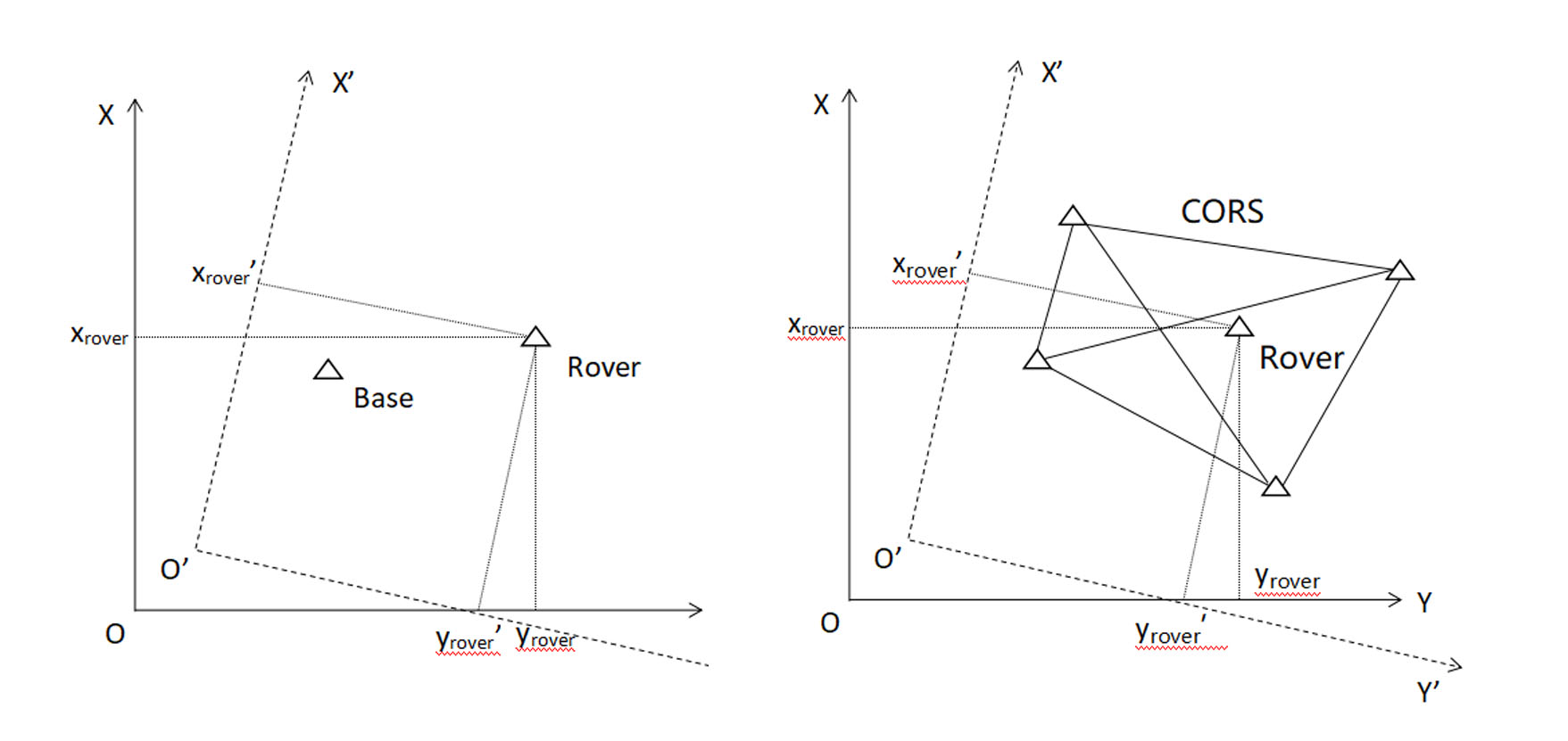
The coordinates of the base or the coordinates of the CORS station
are different in the two coordinate systems.
And the coordinates of the rover are also different.
In order to make the coordinate system in the area conform to the external control point coordinate system, or to achieve uniformity between the two coordinate systems in an are, the Site Calibration is required.

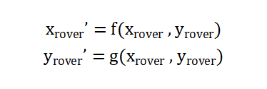
The conversion of north and east 2D coordinates (plane adjustment) consists of 2 translation parameters, 1 rotation parameter and 1 scaling parameter between the two coordinate systems.
In the elevation direction, there are different methods of converting elevation coordinates such as fixed difference correction, plane fitting and surface fitting. The fixed difference correction considers the conversion to be completed by a fixed value, whereas the plan fitting and surface fitting consider that the difference between two elevation systems will be different at different locations and fit the difference by a plane defined by 3 parameters or a surface defined by 6 parameters.
How to perform Site Calibration

There are 4 parameters to be calculated in the plane adjustment, so 2 points are required at least. It is generally recommended to select more than 3-4 points and obtain the coordinates of these points in both target system and current system for the plane adjustment, so that there are extra observations to calculate the residuals to further check errors. The height fitting has 1,3 or 6 parameters to be calculated depending on the method and requires 1,3 or 6 pairs of coordinate values at least.
When selecting the points to be used for Site Calibration, it is desirable that these points are distributed around the edges of the working area, so that the points control the whole area. And try to avoid having several points in a straight line.

The points chosen in the left picture makes more sense.
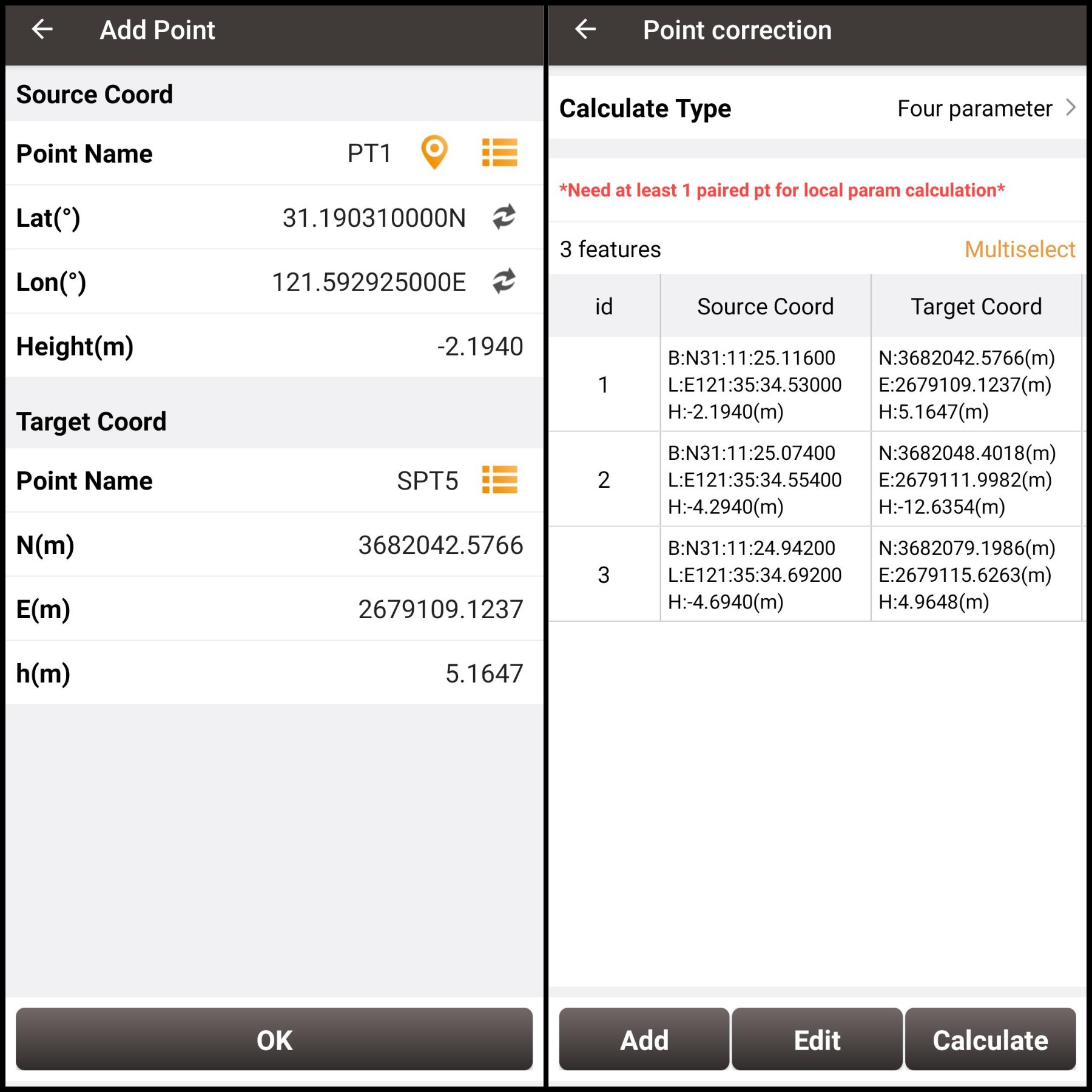
In addition, only 1 pair of coordinate values to perform plane adjustment is supported in Tersus Nuwa App to calculate only the translation values. It also supports Site Calibration during or after the completion of RTK survey, where the coordinates in the Point database will be recalculated according to the Site Calibration parameters.
About Tersus GNSS Inc.
Tersus GNSS is a leading Global Navigation Satellite System (GNSS) solution provider. Our offerings and services aim to make centimeter-precision positioning affordable for large-scale deployment.
Founded in 2014, we have been pioneers in design and development GNSS RTK products to better cater to the industry’s needs. Our portfolios cover GNSS RTK & PPK OEM boards, David GNSS Receiver, Oscar GNSS Receiver, MatrixRTK [GNSS CORS Systems] and inertial navigation systems.
Designed for ease of use, our solutions support multi-GNSS and provide flexible interfaces for a variety of applications, such as UAVs, surveying, mapping, precision agriculture, lane-level navigation, construction engineering, and deformation monitoring.
Sales inquiry: sales@tersus-gnss.com
Technical support: support@tersus-gnss.com
