What is RTCM? Why does RTK firmware updating matter?
Lance Dong, Tersus GNSS 8 April, 2022
What is RTCM?
In order to improve the accuracy and reliability of real-time positioning, real-time differential GPS technology is widely used in current surveying operations. The differential system consists of the base station, data link, and user (rover). Among them, the data link plays a key role in the system, and whether it is effective and reliable determines whether the differential system is reliable and effective. The differential protocol is an important part of the data chain. Any data information has its own way of being generated, stored and exchanged. This way of existence is the protocol. To facilitate the exchange and transmission of information, the need for a unified format protocol emerges as the times require, resulting in a standard protocol used by differential systems around the world. Currently, the most commonly used differential message formats are RTCM SC-104 and CMR. Here we focus on RTCM.
In November 1983, the Radio Technology Commission for Maritime Services (RTCM for short) established the SC-104 special committee for the global promotion of differential GPS services to formulate various data format standards.
Version 1
The original SC-104 work was published as a preliminary standard in 1985, but it was never widely adopted. It was superseded by version 2, which was very similar.
Version 2
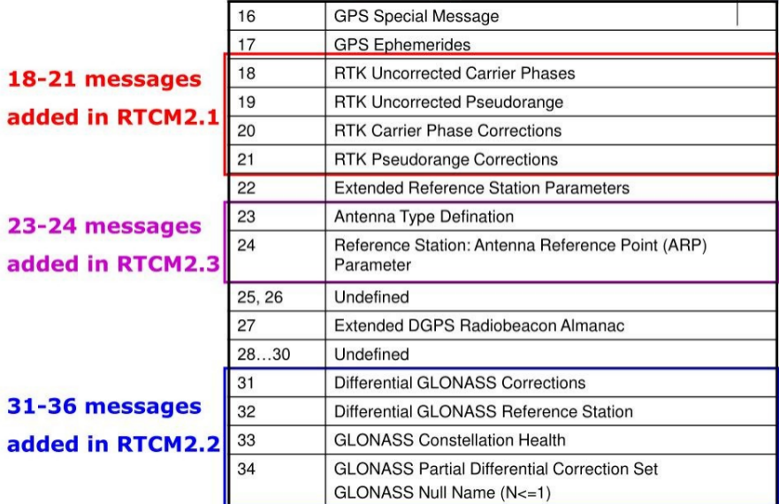
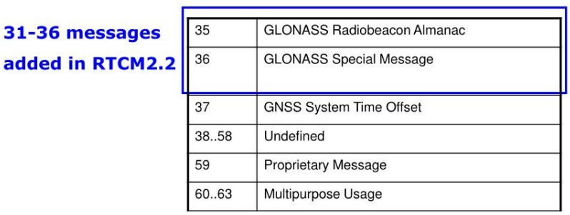
In 1990, the v2.0 version was released. This version only has pseudo-range difference information and no carrier phase. It mainly serves navigation applications. Subsequently, in order to meet the needs of carrier phase difference technology, the V2.1 version was officially announced in 1994, and the V2.2 version in 1997 supported the Russian GLONASS differential message. The last update to version 2.3 was released in August 2001.
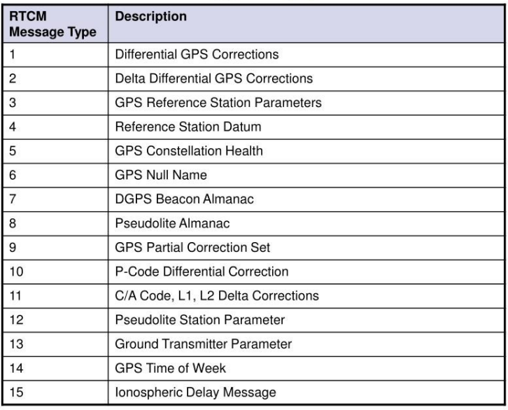
A total of 64 message types Were allowed, including some reserved for future expansion, or rarely used formats that have since been abandoned. The original standard for version 2 included six message formats: 1 for differential data, 2 for updating previous differentials, 3 for station location data, 6 as a null message to fill unused slots, 16 included for sending test messages of an arbitrary 90 ASCII characters, and 59 for proprietary messages used by equipment vendors. Since 1994, the message type has been continuously updated, and such as antenna ID and description in Type 23, and antenna height in Type 24 have been added to the V2.3 version.


>About the CMR format
Due to RTCM2.x's fixed-width packets and extensive error correction, the effect is poor in RTK usage with relatively high message loads. Trimble introduced its own Compact Measurement Record (CMR) format in 1996 and the updated CMR+ the following year. CMR format meets the requirements of low-bandwidth communication, while RTCM2.x, as an earlier international format, can also be used for the pseudo-range difference.
However, in the era of RTCM3.x, these two formats are not recommended compared to RTCM3.
Version 3
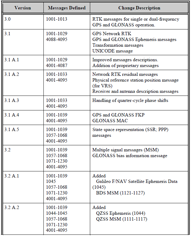
The third edition of the standard in 2004 introduced a new message format for RTK, multi-galaxy, which uses a variable-length format to improve efficiency and increase the number of messages that can be sent, which is important for real-time differentials. The naming of version 3.1 was also changed to RTCM 10403.1, and as of May 20, 2021, the latest version is 3.3 or 10403.3.
The continually updating new standard also greatly increases the number of possible message types. With new message types defined, RTCM 3 is specifically designed to make it straightforward to accommodate new systems that are under development, such as network RTK supported, new satellite systems BDS and Galileo messages supported, as well as modifications to existing systems (e.g., new L2C and L5 signals). A summary of the version history of the RTCM 10403 standard series is shown below.


Why does your RTK firmware updating matter?
It is not difficult to see that, with the development of technology and the increase in demand, especially the introduction of new systems such as Galileo and Beidou, and the addition of network technology, RTCM has been updated several times since the first version was implemented as an international format standard.
As a self-developed high-precision RTK supplier, Tersus GNSS is also closely following the protocol standard for version updates. At present, the differential formats supported by our RTK are RTCM2.3, RTCM3.0, RTCM3.2, CMR and CMR+, and the Tersus technical team is still continuing to supplement and update according to the changes in the standard and the specific needs of customers in practical applications, and make corrections according to the decoding problems that occur when broadcasting and receiving RTCM data, and make corrections according to RTCM-related decoding problems or bugs caused by the frequency update of the Beidou satellite system. The data message standard is not only related to communication, but also to the accuracy of positioning. Therefore, the selection of differential format should be carefully considered in differential positioning, and the version of RTK should be upgraded in time to ensure that the data obtained in the measurement work is reliable, and of high precision.
Reference: RTCM Special Committee NO. 104. RTCM Recommended Standards for Differential GNSS [S]. Radio Technical Commission for Maritime Services, 1998.
RTCM Official Website: http://www.rtcm.org/
WIKIPEDIA: RTCM SC-104 - Wikipedia
About Tersus GNSS Inc.
Tersus GNSS is a leading Global Navigation Satellite System (GNSS) solution provider. Our offerings and services aim to make centimeter-precision positioning affordable for large-scale deployment.
Founded in 2014, we have been pioneers in design and development GNSS RTK products to better cater to the industry’s needs. Our portfolios cover GNSS RTK & PPK OEM boards, David GNSS Receiver, Oscar GNSS Receiver, MatrixRTK [GNSS CORS Systems] and inertial navigation systems.
Designed for ease of use, our solutions support multi-GNSS and provide flexible interfaces for a variety of applications, such as UAVs, surveying, mapping, precision agriculture, lane-level navigation, construction engineering, and deformation monitoring.
Sales inquiry: sales@tersus-gnss.com
Technical support: support@tersus-gnss.com
