What is RTK? How to evaluate RTK receiver for land survey?
Min Chen, Tersus GNSS 18 April, 2022
RTK (real-time Kinematic) is a real-time kynamic relative positioning technology using carrier phase observation, which can provide real-time 3D positioning results in a specified coordinate system and achieve centimeter-level accuracy.
The principle of RTK is to set up a base station on a known or unknown points, it continuous receives all visible GNSS satellite signals, and sends the base coordinates, pseudorange observation, carrier phase observation to the rover through wireless data link (network, radio, etc.). When the rover receives the data from the base, it synchronously observes and collects the carrier phase data of GNSS satellites. The integer ambiguity of carrier phase is fixeded through double-differential carrier observation, and the high-precision coordinates of the rover are obtained according to Integer ambiguity resolution.
RTK receiver for Land Surveying is a receiver that uses RTK technology to carry out precise land surveying and engineering survey. There are many brands of RTK receivers in the market, and the RTK performance has its own advantages and disadvantages. So how to evaluate the RTK positioning performance of a RTK receiver for land surveying?
We think we can evaluate it in the following ways:
· Satellite tracking capability
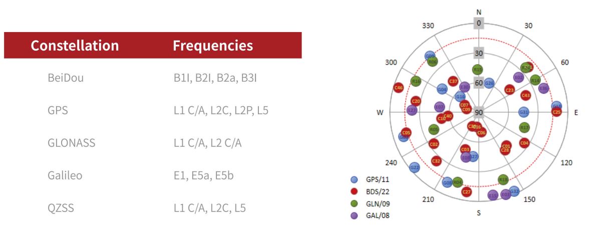
With the rapid development of GNSS industry, the number of satellites that can be used for positioning is increasing, and RTK receiver is constantly updated to support more satellite systems and frequencies. In recent years, with the completion of the network of the Beidou-3 satellites, a multi-constellation and multi-frequency RTK receiver that can support the Beidou-3 satellites, GPS, GLONASS, GALILEO and so on, can easily track 50+ satellites. It can also obtain high-precision positioning results in urban canyons and dense forests where the ordinary receiver cannot work due to the lack of satellite tracking ability. Oscar GNSS Receiver is one such new RTK receiver for surveying.
With ExtremeRTKTM technology, Oscar GNSS receiver can simultaneously track the satellite signals of 16 frequencies in the five constellations of BDS-2/BDS-3, GPS, GLONASS, Galileo, and QZSS. The continuous optimization of GNSS high-precision baseband IC (integrated circuit) and RTK algorithm enables Oscar to not only search more satellites, but also effectively filter out signals with serious multipath error and low signal-to-noise ratios. Being able to perform in all sky-view-scenarios, weather, and various multipath profile environments, Oscar has greatly broadened the application of RTK for surveying.
· RTK measurement accuracy
If the powerful satellite tracking capability is the cornerstone of RTK receiver, then the measurement accuracy is the soul of RTK receiver, RTK receiver is the most important ability is to measure accurately, no error. In order to fully evaluate the RTK positioning accuracy of a receiver, we can measure it by the following methods.
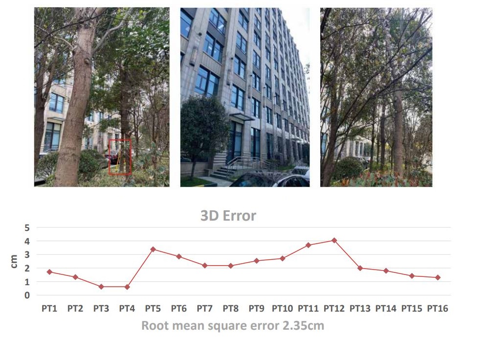
(1) Select two scenarios, open sky and challenging environment, to measure the same point in different time periods, and count the accuracy. In the challenging environment, we can also test whether there are gross errors. The method is to reset RTK and repeat the measurements several times to see whether there is an error of decimeter level or above.
(2) Select two scenarios of open sky and challenging environment, and use RTK continuous point measurement mode to collect points for a period of time, and count the accuracy.
The following figure shows the accuracy of Oscar receiver in open sky by method (1). Refer to DG/TJ08-2121-2013 "Shanghai Engineering Construction Specification- Technical Specification for Satellite Positioning Measurement"(hereinafter referred to as the Shanghai Specification). Four time periods within three days were selected, and RTK reset was performed 8 times in each time period. Two groups of data were collected during each RTK reset, and 16 groups of data were collected in a single time period, and 66 groups of data were collected in four time periods. From the table below, we can see that, under a more stringent surveying environment than required, the difference during the single period and the error RMS (Root Mean Square) in each period both meet the requirements of the Shanghai Specification.

The following figures show the challenging environment and the accuracy of Oscar receiver by method (1). Four time periods are also selected, and Oscar receiver is restarted at each time period to reset RTK. One group of data is collected in each direction of east/west/south/north, and four groups of data are collected in a single time period, with a total of 16 groups of data collected. According to statistical analysis, the maximum value of 3D error was 4.0cm and the minimum value was 0.6cm. The percentage of points with a 3D error less than 3cm was more than 81%. The 3D error RMS was 2.35cm, which met the requirement of detail point surveys.
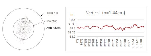
The following figure shows the accuracy of Oscar receiver in open sky by method (2), continuous observation of 1200 points, a total of about 1.7 hours, the statistical plane median error is only 0.64cm, elevation median error is only 1.44cm.
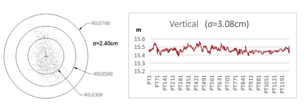
The following figure shows the accuracy of Oscar receiver in challenging environment by method (2), with 10-story building and dense tree canopy, the horizontal error of 1200 points in 1.7 hours is only 2.40cm and the vertical error is only 3.08cm. Thus it is a verification that ExtremeRTKTM is fully qualified for all scenarios.
· RTK fix speed
It refers to the time required from the rover receiving corrections of the base to obtaining fixed solution during RTK positioning. The main factors affecting the fixed speed of RTK include the number of tracking satellites, satellite distribution, observation environment and the performance of RTK algorithm.
We can evaluate the fix speed of an RTK receiver in the following way:
(1) Choose two scenarios: open sky and challenging environment. And count the time required from receiving the corrections to obtaining the fixed solution.
(2) Use another brand receiver for comparative test. Use the same base station and choose different challenging environments, such as next to tall buildings and under trees, etc., and make statistics on whether the two can obtain fixed solutions or the time to fix. This method can directly compare the fix speed and capability of the two.
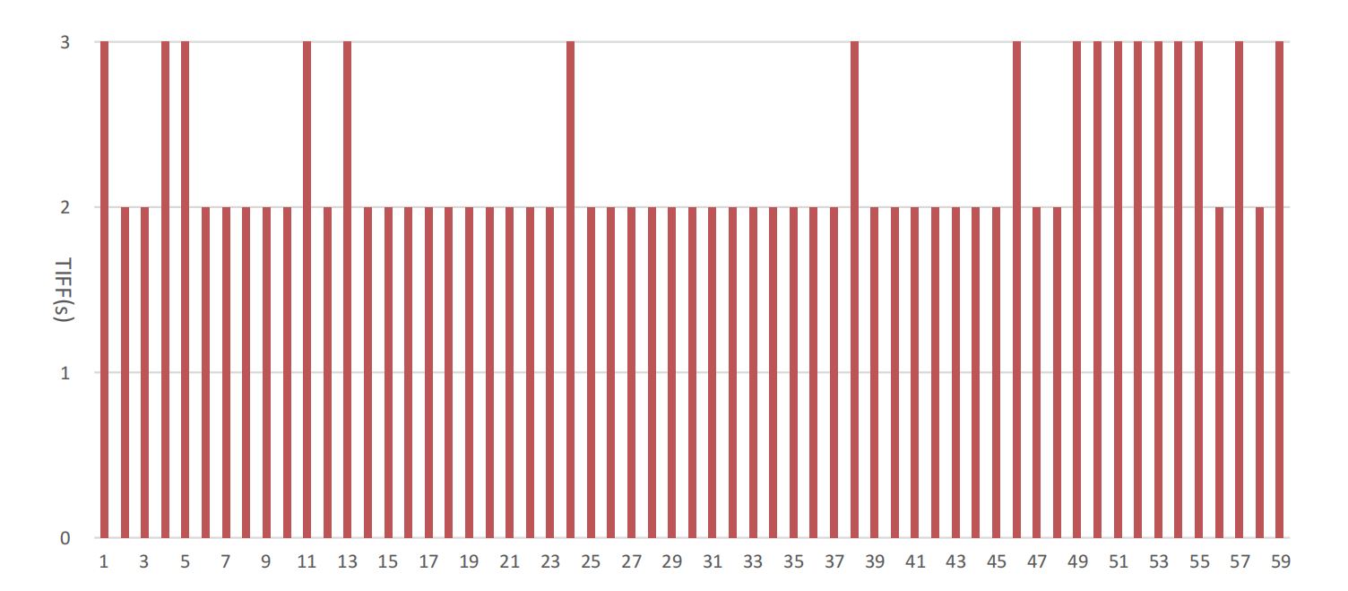
The figure below shows the time to fix of Oscar receiver in open sky. The tests adopt a Tersus base station, with a baseline distance of 15km, and an open sky environment. We use the state identifier in the GPGGA data stream and count the duration from receiving the first packet of correction data to a fixed RTK state, as TTFF (time to first fix). A total of 59 RTK resets were done; each RTK reset is a full re-initialization (ambiguity resolution). The Oscar receiver TTFF is shown in figure 3.1. It can be seen that in open sky, the shortest TTFF is about 2s, the longest is about 3s, and the average time is 2.29s, which truly reflects the excellent performance of getting fixed in seconds.
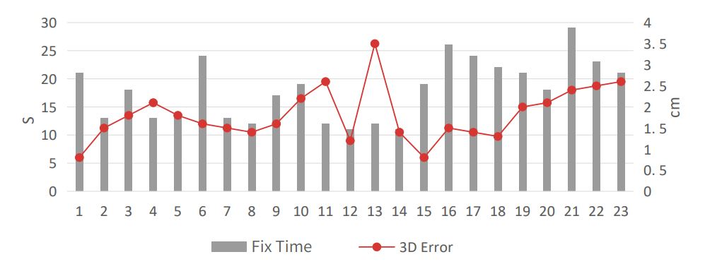
The figures below show the challenging environment and the time to fix of Oscar receiver.
This scenario has multipath reflection error caused by glass and hard walls as well as scattering multipath error caused by dense tree canopy. Similar to the open sky scenario, we conduct the RTK reset 23 times to determine the RTK fix speed performance. After each reset, one measurement is conducted at the reference point. In this test, the shortest RTK fixed time is 11 seconds, the longest is 29 seconds, and the average is 17.9 seconds. The measured value is 3.5cm of maximum error and 0.8cm of minimum error from the true value (3D Error), fully meets the measurement specification.
Of course, there are other aspects to evaluate the performance of an RTK receiver, for example, whether it supports new measurement techniques such as tilt measurement, visual measurement, etc. But no matter what technology is been used, we think RTK accuracy is always the most important.
About Tersus GNSS Inc.
Tersus GNSS is a leading Global Navigation Satellite System (GNSS) solution provider. Our offerings and services aim to make centimeter-precision positioning affordable for large-scale deployment.
Founded in 2014, we have been pioneers in design and development GNSS RTK products to better cater to the industry’s needs. Our portfolios cover GNSS RTK & PPK OEM boards, David GNSS Receiver, Oscar GNSS Receiver, MatrixRTK [GNSS CORS Systems] and inertial navigation systems.
Designed for ease of use, our solutions support multi-GNSS and provide flexible interfaces for a variety of applications, such as UAVs, surveying, mapping, precision agriculture, lane-level navigation, construction engineering, and deformation monitoring.
Sales inquiry: sales@tersus-gnss.com
Technical support: support@tersus-gnss.com
