RTCM 3.1 Transformation Messages 1021-1027 Decoder in Tersus Nuwa
Chenge Zang, Tersus GNSS 27 October, 2022
As we all know, RTCM messages are used for sending differential GNSS correction data to a GNSS receiver as a rover from a source like a base receiver or CORS Service. And the users of GNSS services normally present their results in the coordinates of regional or local horizontal and vertical datum systems, so the coordinate transformations are necessary. In most cases, the transformation parameters can be set in the field application such as Tersus Nuwa, if the parameters are already known or required by local organizations. Another higher accuracy way here is that the transformation parameters and geoid/grid models would be pre-calculated, generally by CORS service based on the location reported by the rover and then transmitted in RTCM 1021-1027 messages to the GNSS controller.
The RTCM3.1 transformation messages includes seven different messages, from 1021 to 1027. These messages could be further classified into several types, as the messages are defined for the applications, corresponding for example to Tersus Nuwa, they are the three-dimensional datum transitions from source coordinate system, which is provided directly by GNSS positioning service, to target coordinate system locally, transitions from XYZ to BLH with target ellipsoid model, a respective projection, and height fitting models from GNSS height over ellipsoid to target height. In these above, on the basis of three-dimensional datum transitions with Molodensky models or Molodensky-Badekas models, or in the case of height fitting, the introduction of the plane or vertical “residual grids”, namely the residual matrix grid values obtained by interpolation calculation, will result in a higher accuracy coordinates after transformation over a larger range.
More specifically, in the seven RTCM3.1 transformation messages, the messages 1021 and 1022 define the parameters of the basic three-dimensional datum transformations and the ellipsoid model for transition. Only one of the two will be provided, depending on the transformation type being 7 parameters Molodensky model or 10 parameters Molodensky-Badekas model.
The messages 1023 and 1024 define the horizontal residuals and vertical residuals for the grid, while message 1023 provides latitude and longitude residuals related to the ellipsoid and message 1024 provides north and east residuals related to the projection types defined messages 1025 to 1027.
The message types 1025, 1026 and 1027 are all related to the projection parameters. Message 1025 provides the parameters for standard projections, like Transverse Mercator, while messages 1026 and 1027 provides the parameters for Lambert Conformal Conic projections and Oblique Mercator projection respectively.
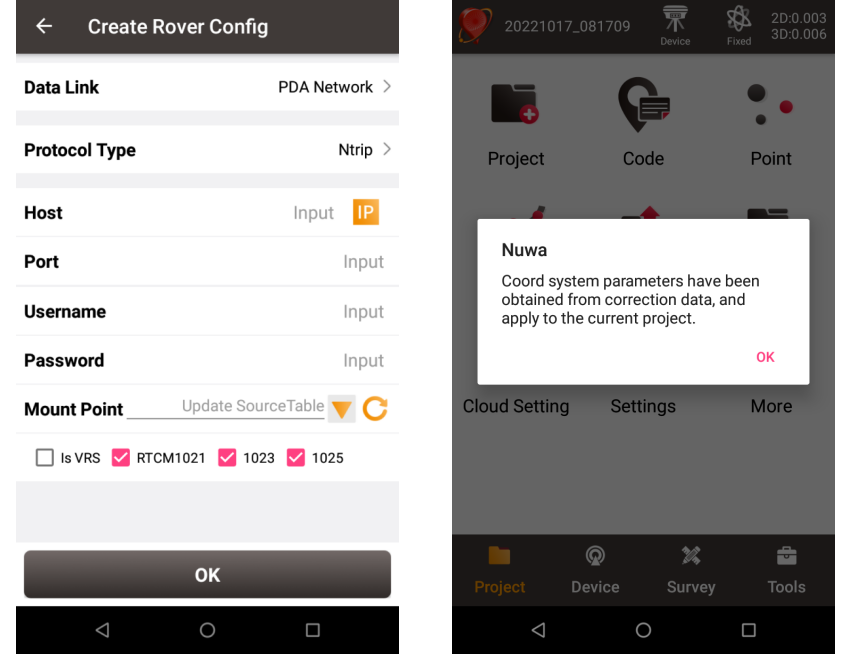
RTCM3.1 transformation messages 1021-1027 decoder has been designed to work in NTRIP connection rover mode in Tersus Nuwa. Currently, messages 1021, 1023 and 1025 decoding has been implemented and is sufficient for most cases. We have set several checkboxes in the interface of NTRIP connection rover mode configuration, and if the user needs the transformation parameters broadcast from Caster in CORS NTRIP service and has confirmed there would be messages 1021-1027 in the correction data, the check box could be checked and the parameters in project property will be overwritten after the transformation messages are received and decoded. At that point, we recommend not to edit the parameters manually, especially by turn off the Dynamic Grid Parameters button in the ellipsoid model interface, as the residual grid values involved in the coordinate transformation calculation will be changed at any time depending on the position change reported to Caster with GGA statement.

In another situation, if the user has entered his correct project property parameters and is not interested in transformation messages, or some of parameters in messages, even if messages 1021-1027 are all transmitted in the correction data, it is possible to avoid the parameters being overwritten and getting wrong results, as long as the corresponding checkboxes are not checked.
About Tersus GNSS Inc.
Tersus GNSS is a leading Global Navigation Satellite System (GNSS) solution provider. Our offerings and services aim to make centimeter-precision positioning affordable for large-scale deployment.
Founded in 2014, we have been pioneers in design and development GNSS RTK products to better cater to the industry’s needs. Our portfolios cover GNSS RTK & PPK OEM boards, David GNSS Receiver, Oscar GNSS Receiver, MatrixRTK [GNSS CORS Systems] and inertial navigation systems.
Designed for ease of use, our solutions support multi-GNSS and provide flexible interfaces for a variety of applications, such as UAVs, surveying, mapping, precision agriculture, lane-level navigation, construction engineering, and deformation monitoring.
Sales inquiry: sales@tersus-gnss.com
Technical support: support@tersus-gnss.com
