Definition and Uses of TIN Surface
Chenge Zang, Tersus GNSS 12 May, 2022
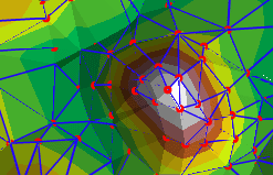
Triangular Irregular Network (TIN) surface, as the name explains, is a type of vector-based surface network data consisting of a series of irregular triangles. Digital Elevation Model (DEM) is more commonly referred to in the surveying field, to define regional elevation topographic data for data exchange between different software. And TIN is a typical type of DEM. In addition to this, DEM has various forms such as raster map, contour lines, and regular grid, etc.
How is the triangular network in the TIN surface defined, and how are the vertices connected into edges and then into triangles? In fact, there are many ways to form these triangles, and here we will introduce Delaunay triangle method, which is also used in Tersus Nuwa software.
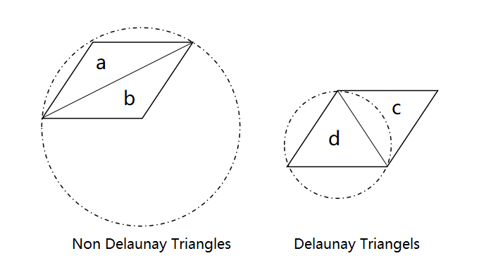
The principle of generating Delaunay triangles is that no vertex will fall inside the outer circle of any other triangles (a triangle that does not contain that point). This principle will make the minimum interior angles in Delaunay triangles all as large as possible, which will reduce the number of long, thin triangles in the triangular network, will make the triangular network pleasing and reliable, and will also bring the results closer to the actual values when using TIN for interpolation calculations.

TIN surface can be used in a variety of scenarios. In engineering applications, they are often used to calculate area, surface area and volume. For example, in Earthwork calculation, TIN surface is generated by the points measured in the area, and then the volume between TIN surface and the design surface can be calculated.
In the process of collecting the points with elevation as the vertices constituting TIN surface for earth volume calculation, you can use the Tersus rod-tip roller to collect along the boundary of the area extent to draw the boundary curve, to avoid Delaunay triangles may be incorrectly added or subtracted due to the irregular boundary, making TIN surface inconsistent with the area extent referred to by the actual surface. In addition, the collection points should be encrypted especially in areas with large elevation changes or complex terrain. The denser the vertices, it means the accuracy will be improved and TIN surface will be closer to the terrain.

In Tersus Nuwa software, using the Earthwork tool, select the vertex collection points that need to form TIN surface, and select the boundary points in order as needed, the software will automatically generate TIN surface according to Delaunay rule and calculate the volume value between TIN surface and the design surface.
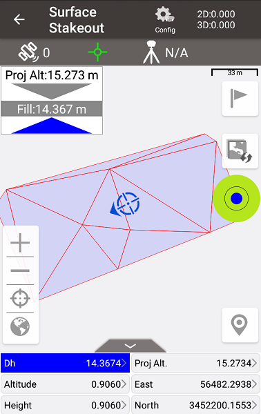
Besides, when there is already TIN surface design data, for example a DXF file with 3dface or vertices and their topological relations in a Landxml file, it is possible to perform a surface stake to calculate the cutting or filling at each place to change the current land surface to the TIN design surface.
In this process, the horizontal and vertical coordinates can be obtained using Tersus GNSS receiver Oscar. The horizontal coordinates are used to determine which specific triangle the current position within (or on the boundary of the triangle) in the TIN design surface, and the design height at the current position is interpolated by the vertices elevation of that triangle, then the difference between the current elevation and the design height can be calculated.
In Tersus Nuwa software, using the Surface Stakeout module, import a DXF or LandXML drawing and select it, then the software will automatically indicate the design height and the cut or fill value.

About Tersus GNSS Inc.
Tersus GNSS is a leading Global Navigation Satellite System (GNSS) solution provider. Our offerings and services aim to make centimeter-precision positioning affordable for large-scale deployment.
Founded in 2014, we have been pioneers in design and development GNSS RTK products to better cater to the industry’s needs. Our portfolios cover GNSS RTK & PPK OEM boards, David GNSS Receiver, Oscar GNSS Receiver, MatrixRTK [GNSS CORS Systems] and inertial navigation systems.
Designed for ease of use, our solutions support multi-GNSS and provide flexible interfaces for a variety of applications, such as UAVs, surveying, mapping, precision agriculture, lane-level navigation, construction engineering, and deformation monitoring.
Sales inquiry: sales@tersus-gnss.com
Technical support: support@tersus-gnss.com
