Beidou in the starry sky
Lance Dong, Tersus GNSS 15 September, 2022
Whether it is the Big Dipper in the night sky or the current Beidou Navigation Satellites System, they seem to be very magical "stars". Let us approach Beidou together and learn more about the secrets of the Beidou.
Beidou Navigation Satellite System (hereinafter referred to as BDS) is a global navigation satellite system independently constructed and operated by China. BDS is an important national space-time infrastructure that provides global users with all-weather, all-day, high-precision positioning, navigation and timing services.

Development History
In the late 20th century, China began to explore the development path of satellite navigation systems suitable for its national conditions, and gradually formed a three-step development strategy: at the end of 2000, the Beidou-1 systemwas built to provide services to China; at the end of 2012, the Beidou-2 system was built, Provide services to the Asia-Pacific region; in 2020, build the Beidou-3 system to provide services to the whole world.
◆ The first step: BDS-1, "create something out of nothing"
In 1994, the construction of Beidou-1 system was started. From 2000 to 2003, 3 Geosynchronous Earth Orbit (GEO) satellites were launched, and the Beidou navigation satellite test system was initially built. Active positioning system was adopted to provide Chinese users with positioning, timing, wide-area differential and short message communication services .
◆ The second step: BDS-2, steadily expanding
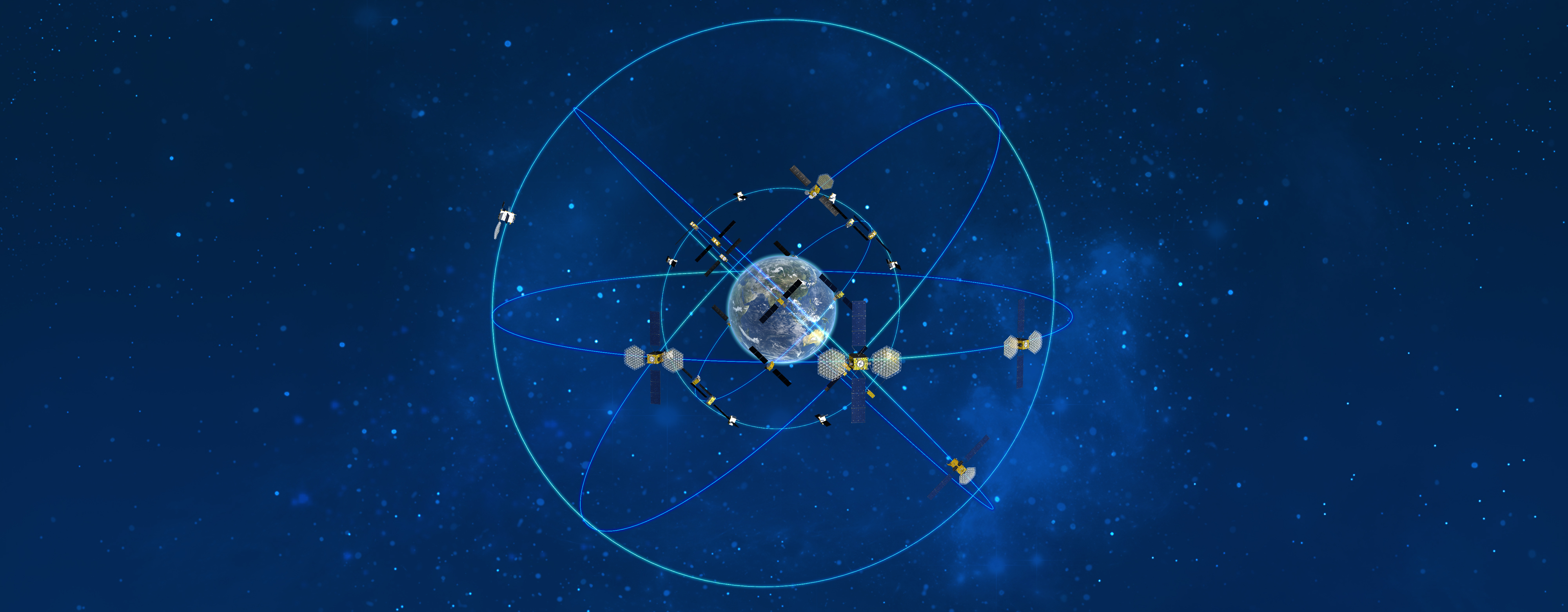
In 2004, the construction of Beidou-2 system was started. In 2012, 14 satellites, namely 5 Geosynchronous Earth Orbit (GEO) satellites, 5 Inclined Geosynchronous Orbit (IGSO) satellites and 4 Medium Earth Orbit (MEO) satellites, were launched and networked. BDS-2 creatively proposed a new Chinese solution for the development of the global navigation satellite system, which is, the 5GEO+5IGSO+4MEO mixed constellation framework for medium and high orbits. BDS-2 has added a passive positioning system, and expanded to provide positioning, speed measurement, timing and short message communication services in the Asia-Pacific region.
◆ The third step: BDS-3, servicing global
In 2009, the construction of the Beidou-3 system was started. In 2020, the Beidou-3 system was fully completed, consisting of 3GEO+3IGSO+24MEO to form a hybrid navigation constellation, inheriting the positioning system combining active and passive. The services of BDS have been extended from regional to global, providing basic navigation (positioning, speed measurement, timing), global short-message communication and international search and rescue services for global users. as well as BDS-3 provides regional short-message communication, services such as satellite-based enhancement and precise point positioning.
The difference between BDS-3 and BDS-2 is not only that the satellite network has moved from regional to global, but also has progressed in terms of payload, inter-satellite link, and laser communication. For example, Beidou- 3 uses a space-borne hydrogen atomic clock, and its accuracy will be an order of magnitude higher than the space-borne rubidium atomic clock of Beidou-2. The design performance is better than Russia's GLONASS and comparable to the third-generation GPS.
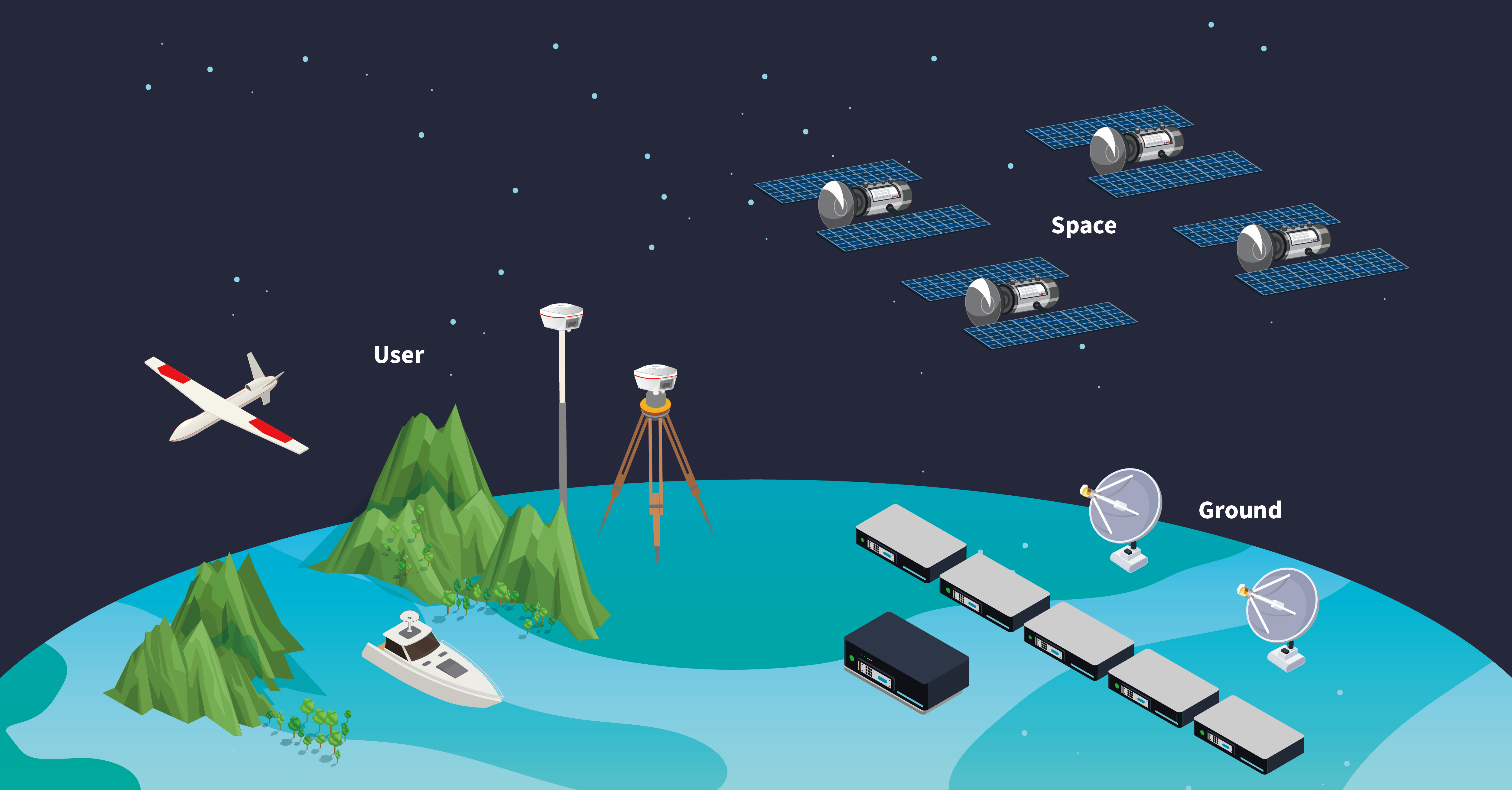
The three-segment composition of the BDS

◆ Space Segment: The constellation composed ofGEO, IGSO and MEO satellites of the Beidou satellite system.
◆ Ground Segment: The ground segment includes ground stations such as the main control station, time synchronization/stream injection station and monitoring station, as well as inter-satellite link operation management facilities.
◆ User Segment: The user segment includes basic products such as chips, modules, and antennas compatible with BDS and other navigation satellite systems, as well as terminal equipment, application systems and services. Products like our Oscar receiver from Tersus GNSS belong to the user segment.
The Three Brothers
Three types of satellites make up the BDS constellation: Geosynchronous Earth Orbit (GEO) satellites, Inclined Geosynchronous Orbit (IGSO) satellites, and Medium Earth Orbit (MEO) satellites. According to their own orbital characteristics and functions, each satellite jointly provides high-quality positioning, navigation and timing services for global users.
◆ Geosynchronous Earth Orbit (GEO) Satellites
GEO satellites are fixed at about 36,000 kilometers above the equator. In theory, the sub-satellite point trajectory (the projection of the satellite's orbit on the earth) is a point. Its operation period is the same as the rotation period of the earth, so it remains stationary relative to the ground.
The single-satellite signal coverage of GEO satellites is very wide.
Generally speaking, three GEO satellites can achieve signal coverage to most areas of the world (except the North and South Pole). Because of its high orbit and good shielding resistance, it has obvious application advantages in cities, canyons, mountains and other regions.
◆ Inclined Geosynchronous Orbit (IGSO) satellites
IGSO satellites, the orbital altitude is also 36,000 kilometers, and the operation period is also the same as the rotation period of the earth, but its orbital plane has a certain angle (55°) with the equatorial plane. Because of the specific angle with the equator, its subsatellite point trajectory is in the shape of an "8" across the northern and southern hemispheres.
As a high-orbit satellite, the IGSO also has a strong signal anti-blocking ability. Given that the special operating orbit, the combination of IGSO satellites and GEO satellites can more optimally solve the problem of poor signal coverage in high latitude regions caused by the low elevation angle of GEO satellites.
◆ Medium Earth Orbit (MEO) Satellites
MEO satellite has an orbital altitude of 20,000 kilometers and an orbital inclination of 55. The operating period MEO satellites is shorter than the Earth's rotation period, which is 13 laps in 7 days. Run tirelessly and quickly around the earth, so that the sub-satellite point trajectory is a wavy line across the equator.
Theoretically, multiple MEO satellites can be networked to achieve global coverage.
Reference: http://www.beidou.gov.cn/
About Tersus GNSS Inc.
Tersus GNSS is a leading Global Navigation Satellite System (GNSS) solution provider. Our offerings and services aim to make centimeter-precision positioning affordable for large-scale deployment.
Founded in 2014, we have been pioneers in design and development GNSS RTK products to better cater to the industry’s needs. Our portfolios cover GNSS RTK & PPK OEM boards, David GNSS Receiver, Oscar GNSS Receiver, MatrixRTK [GNSS CORS Systems] and inertial navigation systems.
Designed for ease of use, our solutions support multi-GNSS and provide flexible interfaces for a variety of applications, such as UAVs, surveying, mapping, precision agriculture, lane-level navigation, construction engineering, and deformation monitoring.
Sales inquiry: sales@tersus-gnss.com
Technical support: support@tersus-gnss.com
