What is SLR and VLBI?
Chenge Zang, Tersus GNSS 25 Dec. 2023
Satellite Laser Ranging (SLR) and Very-Long-Baseline Interferometry (VLBI) both belong to the modern geodetic technique used by the International Earth Rotation Service (IERS). They are both technologies developed in the 1960s and 1970s, which have improved the measurement accuracy in the field of astrometry compared with the classical measurement techniques of the same period. In this paper, the definitions and applications of SLR and VLBI are presented.
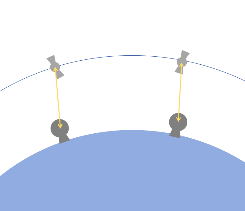
Laser ranging is a very commonly used method of distance measurement. The principle of laser pulse measurement is to calculate the distance between two points by determining the round-trip propagation time of the pulse signal. SLR is the technology for determining the distance between a ground station and an artificial satellite by accurately determining the time between the round-trip propagation, which is emitted by the ground station and reflected to the ground station by the satellite installed with (or without) laser reflecting prisms.

The accuracy of SLR, that is, the accuracy of the round-trip time of the laser pulse, is affected by the laser pulse width, which has been upgraded from the first-generation pulse width of 10-40ns and ranging accuracy of about 1-6m to the third-generation pulse width of 0.1-0.2ns and ranging accuracy of 1-3cm, which is one of the highest accuracy of single-point positioning of satellites. The errors of SLR also include the deviation of the laser reflection point of the satellite and the center of the satellite, the atmospheric effect and relativistic effect in the process of light propagation, the influence of tides and plate movement of the ground observatory, the delay of the signal of the ground system and the correction of the observation time, and so on.
Currently, the main applications of SLR include the establishment and maintenance of global or regional reference frames (e.g., ITRF), the determination of geodynamics such as polar motion and plate motion, the determination of gravity field coefficients, and the precise determination of satellite orbits. Compared to GPS, SLR stations can be commissioned and maintained directly on the ground. When it is used for orbit determination, combining GPS, SLR and DORIS data can improve the positioning accuracy to a certain degree and provide redundant observations to maintain the stability of calculation.
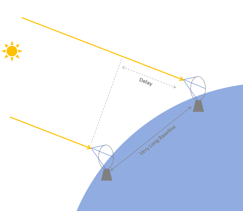
VLBI is a radio interferometry technique. Electromagnetic waves from the same radio source, due to the different positions of the antennas at the two ends of the baseline, are received by the two antennas at different moments, and then interference fringes can be obtained after processing. Due to Earth’s rotation and other spatial changes, the time difference is changing, and if multiple observations are carried out, the position of the radio source and the baseline distance can be further calculated with high precision.

In interferometry, the angular resolution of a radio telescope that receives electromagnetic waves from deep space is proportional to the width of its aperture. VLBI uses two or more telescopes at different locations, through the high-precision atomic clocks and unified playback and processing of recorded observation data in the VLBI data center afterward, the resolution of the observation is only dependent on the distance between telescopes, which is no longer limited to the aperture of the single telescope, and breaks through the limitation of the cable distance in the traditional radio interferometry.
VLBI in astronomical navigation can be used for precise tracking and positioning of spacecraft, such as China's first lunar exploration project in 2004 in which the VLBI orbital system tracked the Chang'e I satellite throughout the whole process. VLBI can also be used in the field of geodesy to solve the problems of Earth positioning and orientation by establishing the reference of extragalactic radio sources, establishing and maintaining the reference system and frame, and determining the plate motion, pole motion, and so on.
About Tersus GNSS Inc.
Tersus GNSS is a leading Global Navigation Satellite System (GNSS) solution provider. Our offerings and services aim to make centimeter-precision positioning affordable for large-scale deployment.
Founded in 2014, we have been pioneers in design and development GNSS RTK products to better cater to the industry’s needs. Our portfolios cover GNSS RTK & PPK OEM boards, David GNSS Receiver, Oscar GNSS Receiver, MatrixRTK [GNSS CORS Systems] and inertial navigation systems.
Designed for ease of use, our solutions support multi-GNSS and provide flexible interfaces for a variety of applications, such as UAVs, surveying, mapping, precision agriculture, lane-level navigation, construction engineering, and deformation monitoring.
Sales inquiry: sales@tersus-gnss.com
Technical support: support@tersus-gnss.com
